


We've collected, computed, or inferred important data such as asteroid mass and composition
 from multiple scientific sources. With this information, we estimate the costs and rewards of mining asteroids.
Details on orbits and basic physical parameters are sourced from the Minor Planet Center and NASA JPL.
Composition data is based on spectral classification and size. Our calculations incorporate conclusions
 from multiple scientific publications in addition to cross-referencing known meteorite data.

NASA Jet Propulsion Laboratory
Published on Feb 27, 2015
Produced in 2007, this overview video about NASA's Dawn mission to giant asteroid Vesta and dwarf planet Ceres

was released before the spacecraft's launch that year. The mission greatly appreciated Leonard Nimoy's support and participation.

Dawn investigated Vesta in 2011-2012, and will arrive at Ceres March 6, 2015. For more information about Dawn,

visit  The dawn Mission
Published on Oct 30, 2015
This simulation shows the trajectory of the asteroid across the sky, showing tracer spheres spaced

at one hour intervals along its path. (A funny frame jump in the middle, apparently the moon got scared, but no time to fix.)
Category
Nonprofits & Activism
License
Standard YouTube License

Map showing TB145’s position for an observer in the north central U.S. at 15-minute intervals starting at 5:00 UT.

Subtract 4 hours from UT for EDT, 5 hours for CDT, 6 for MDT and 7 for PDT. Stars are shown to magnitude +12 and north is up in all maps.

The asteroid is depicted as a small target. Click to enlarge, then save and make a print out for use at the telescope.

 Credit: Chris Marriott’s SkyMap software

Map showing the asteroid’s progress across the horns of Taurus from 9-10:45 UT (4 – 5:45 a.m.) October 31st.

 It passes about 1° northwest of the Crab Nebula around 10:30 UT.

 Credit: Chris Marriott’s SkyMap

The view from the southern U.S. (about 32° latitude) from 11-11:45 UT. Compared to the northern U.S.,

 the asteroid’s path lies about 5 arc minutes further to the north.

 Credit: Chris Marriott’s SkyMap

By this time, TB145 will be around magnitude +10.4 and easier to see than at the start our run.

 The map covers the time from 11-11:45 UT (6 – 6:45 a.m. CDT).

 Credit: Chris Marriott’s SkyMap

Map showing TB145’s approximate path starting at 4 hours UT on Oct. 31 (11 p.m. CDT Oct. 30). This view faces east. Tick marks show its hourly position.

 This map provides context for the detailed maps above.

 Credit: Chris Marriott’s SkyMap
Published on May 11, 2015
The ambitious and exciting Dawn mission is one of NASA's most remarkable ventures into the solar system.

After more than seven years of interplanetary spaceflight, the probe is just a few months away from the mysterious world Ceres.

The spacecraft has already completed a spectacular exploration of Vesta. These were among the last uncharted worlds in the inner solar system

prior to Dawn. They are the two most massive residents of the main asteroid belt, that vast collection of bodies between Mars and Jupiter.

Ceres is so large that it is included in the category of dwarf planets, along with Pluto. The alien landscapes Dawn reveals provide humankind

with a new perspective on the solar system. Remnants from the time that planets were formed, Ceres and Vesta hold clues that will help scientists

understand the dawn of the solar system. Dawn orbited Vesta from July 2011 to September 2012 and returned astonishing views of this fascinating world.

It is the only spaceship ever to orbit an object in the asteroid belt and is the first ever targeted to orbit any two extraterrestrial destinations.

Such a mission would be truly impossible without the use of ion propulsion, a technology that has mostly been in the domain of science fiction.

Dr. Marc Rayman will give a fascinating and entertaining presentation on the Dawn mission and its two exotic destinations as well as its use of ion propulsion.

He also will share the excitement and profundity of controlling a robotic ambassador from Earth in deep space.


Speaker:
Dr. Marc Rayman, Dawn Project Mission Director

Related Media

The von Kármán Lecture Series:
https://www.youtube.com/playlist?list...

Release Date: 05 December 2014

Credit: NASA Jet Propulsion Laboratory (JPL)
Category
Science & Technology
License
Standard YouTube License
Streamed live on Nov 4, 2015
The MISSIONS series at Cross Campus Pasadena continues with the first mission to orbit two mysterious bodies

in our solar system. Mat Kaplan and Emily Lakdawalla will welcome Dawn Mission Director Marc Rayman for this live conversation.

 What are those bright spots on Ceres anyway? Program begins at 7:00pm Pacific.

Category
Science & Technology
License
Standard YouTube License


Artist’s impression of the first interstellar asteroid, "Oumuamua".(1I/2017 U1 )
This unique object was discovered on 19 October 2017 by the Pan-STARRS 1 telescope in Hawaii.
 Credit: ESO/M. Kornmesser
This animation of an artist's concept shows the interstellar asteroid 1I/2017 (`Oumuamua).
 Observations with ESO's Very Large Telescope and others have shown that this unique object is dark,
 reddish in colour and highly elongated.

More information and download options:
For the first time ever astronomers have studied an asteroid that has entered the Solar System
from interstellar space. Observations from ESO’s Very Large Telescope in Chile and other observatories
around the world show that this unique object was travelling through space for millions of years before
its chance encounter with our star system. It appears to be a dark, reddish, highly-elongated rocky
or high-metal-content object.The video is available in 4K UHD.
The ESOcast Light is a series of short videos bringing you the wonders of the Universe in bite-sized pieces.
The ESOcast Light episodes will not be replacing the standard, longer ESOcasts,
but complement them with current astronomy news and images in ESO press releases.

 More information and download options:

 Subscribe to ESOcast in iTunes!

 Receive future episodes on YouTube by pressing the Subscribe button above or follow us on Vimeo:

: Watch more ESOcast episodes

Find out how to view and contribute subtitles for the ESOcast in multiple languages, or translate this video on YouTube:

Credit:
ESO
Category
Science & Technology
License
Creative Commons Attribution license (reuse allowed)
SHOW LESS

vesta

This animation shows the path of 1I/2017 U1, or ‘Oumuamua, as it passed through our inner solar system
in September and October 2017. From analysis of its motion, scientists calculate that it originated
from outside of our solar system.
Credit: NASA/JPL-Caltech

On October 19th, 2017, the Panoramic Survey Telescope and Rapid Response System-1 (Pan-STARRS-1)
 in Hawaii announced the first-ever detection of an interstellar object, named 1I/2017 U1 (aka. ‘Oumuamua).
 In the months that followed, multiple follow-up observations were conducted to learn more about this visitor,
 as well as resolve the dispute about whether it was a comet and an asteroid.
This small object was discovered on October 19, 2017, by the University of Hawaii's Pan-STARRS 1 telescope on Haleakala, Hawaii.
Subsequent observations by ESO’s Very Large Telescope and other telescopes showed that it had come to the Solar System
from interstellar space. 1I/`Oumuamua made its closest approach to the Sun on September 9, 2017. Its hyperbolic orbit
is highly inclined and it does not appear to have come close to any other Solar System body on its way in. 1I/`Oumuamua
is now on its way out of the Solar System.
1I/2017 U1 seems to be a dark red highly-elongated metallic or rocky body, about 400 meters long.
Before receiving the official designation and name `Oumuamua from the International Astronomical Union it was referred to as A/2017 U1
 The name was chosen by the Pan-STARRS team. It is of Hawaiian origin and means "a messenger from afar arriving first."
Credit: ESO, M. Kornmesser, L.Calcada. Music: Azul Cobalto (soundcloud.com/azul-cobalto)
Related: Small Asteroid or Comet 'Visits' from Beyond the Solar System: youtu.be/XD6QCgzwFAA
Astronomers have found that ‘Oumuamua, the first interstellar object discovered in the Solar System,
 is moving away from the Sun faster than expected. Using data from ESO’s Very Large Telescope,
 and from NASA/ESA’s Hubble Space Telescope, a team of researchers concluded that
 ‘Oumuamua is most likely outgassing — suggesting that this enigmatic interstellar
 nomad is a peculiar comet rather than an asteroid.
More information and download options:

 Subscribe to ESOcast in iTunes!

Receive future episodes on YouTube by pressing the Subscribe button above or  follow us on Vimeo:

 Watch more ESOcast episodes:

Find out how to view and contribute subtitles for the ESOcast in multiple languages,  or translate this video on YouTube:

Credit:
ESO

Directed by: Mathias Jäger.
Visual Design and Editing: Martin Kornmesser and Luis Calçada.
Editing: Martin Kornmesser.
Web and technical support: Mathias André and Raquel Yumi Shida.
Written by: Calum Turner and Mathias Jäger.
Music: Stellardrone.
Narration: Sara Mendes da Costa.
Footage and photos: ESO, ESA/Hubble NASA, ESA, Luis Calçada , M. Kornmesser and G. Hüdepohl (atacamaphoto.com).
Executive producer: Lars Lindberg Christensen.
Caption author (Slovak)
Mac Ownick
Caption author (Italian)
Nicola Gaspari
Caption author (French)
Ayoola Boyejo
Caption author (Romanian)
Mihail-Gabriel Barbuta
Caption author (Polish)
Tomasz Kozłowski
Category
Science & Technology
License
Creative Commons Attribution license (reuse allowed)


Image: This artist’s impression shows the first interstellar object discovered in the Solar System,
ʻOumuamua. Observations made with the NASA/ESA Hubble Space Telescope, CFHT, and others,
 show that the object is moving faster than predicted while leaving the Solar System.
 The inset shows a color composite produced by combining 192 images obtained through
 three visible and two near-infrared filters totaling 1.6 hours of integration
 on October 27, 2017, at the Gemini South telescope.
 Credit: ESA/Hubble, NASA, ESO/M. Kornmesser, Gemini Observatory/AURA/NSF.
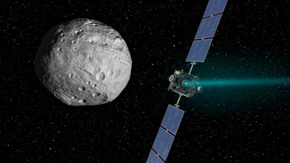
Artist�s concept of the Dawn spacecraft arriving at Vesta. Credit: NASA/JPL-Caltech

Vesta is one of the largest asteroids in the Solar System. Comprising 9% of the mass in the Asteroid Belt,

it is second in size only to the dwarf-planet Ceres. And now, thanks to data obtained by NASA�s Dawn spacecraft,

Vesta�s surface has been mapped out in unprecedented detail.

These high-resolution geological maps reveal the variety of Vesta�s surface features and provide a window into the asteroid�s history.

Vesta shape model from high-altitude mapping orbit(From planetary.org)
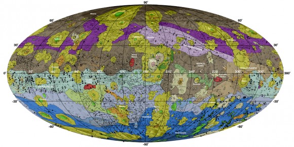
This high-res geological map of Vesta is derived from Dawn spacecraft data. Credit: NASA/JPL-Caltech/ASU

The brown colored sections of the map represent the oldest, most heavily cratered surface. Purple colors in the

 north and light blue represent terrains modified by the Veneneia and Rheasilvia impacts, respectively. Light purples and

 dark blue colors below the equator represent the interior of the Rheasilvia and Veneneia basins. Greens and yellows represent

 relatively young landslides or other downhill movement and crater impact materials, respectively.
by MORGAN REHNBERG on JANUARY 26, 2015

The asteroid Vesta as seen by the Dawn spacecraft. Credit: NASA/JPL-Caltech/UCAL/MPS/DLR/IDA

I don�t think I ever learned one of those little rhymes � My Very Educated Mother Just Served Us Nine Pizzas �

to memorize the order of the planets, but if I had, it would�ve painted for me a minimalist picture of the solar system.

 (Side question: what is my Very Educated Mother serving now that we only have Dwarf Pizzas?) After all,

 much of the most exciting work in planetary science today happens not at the planets, but around them.

Artist�s concept of the Dawn spacecraft arriving at Vesta. Credit: NASA/JPL-Caltech

Vesta is one of the largest asteroids in the Solar System. Comprising 9% of the mass in the Asteroid Belt,

it is second in size only to the dwarf-planet Ceres. And now, thanks to data obtained by NASA�s Dawn spacecraft,

Vesta�s surface has been mapped out in unprecedented detail.

These high-resolution geological maps reveal the variety of Vesta�s surface features and provide a window into the asteroid�s history.

Artist rendition of Dawn spacecraft orbiting Vesta. Credit: NASA/JPL-Caltech

This high-res geological map of Vesta is derived from Dawn spacecraft data.
 Brown colors represent the oldest, most heavily cratered surface.
 Credit: NASA/JPL-Caltech/ASU

The planetoid Vesta, which was studied by the Dawn probe between July 2011 and September 2012.
 Credit: NASA

the brave new world of Vesta, courtesy of NASA's Dawn spacecraft.
 Credit: NASA/JPL-Caltech/UCAL/MPS/DLR/IDA

Vesta and the planet(s)… looking east in early June 2018, about 45 minutes after sunset.
  Credit:Stellerium.org

The path of 4 Vesta through mid-September.
 Credit: Starry Night Education software.

The occultation footprint for the June 27th, 2018 event.
Credit: Occult 4.2 software.

Ceres (left) and Vesta (right) imaged by the Hubble Space Telescope.
Credit: NASA/HST/STl

The south pole Rheasilvia impact basin. Based on images obtained by NASA’s Dawn spacecraft,
 the lower false color map shows the elevation scale scooped out by an ancient impact.
 Credit: NASA/JPL-Caltech/UCLA/MPS/DLR/IDA/PSI

Meteorites recovered on Earth, courtesy of 4 Vesta.
Credit: NASA/University of Tennessee.


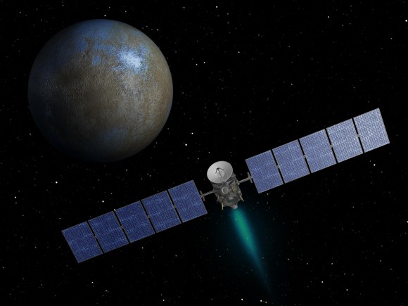
Artist�s conception of the NASA Dawn spacecraft approaching Ceres. Credit: NASA

NASA�s Dawn spacecraft experienced technical problems in the past week that will force it to arrive at dwarf planet Ceres

one month later than planned, the agency said in a statement yesterday (Sept. 16, 2014).


Controllers discovered Dawn was in safe mode Sept. 11 after radiation disabled its ion engine,

 which uses electrical fields to �push� the spacecraft along. The radiation stopped all engine thrusting activities.
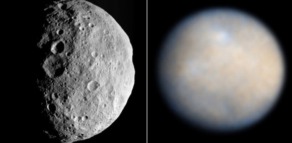
Vesta (left) and Ceres. Vesta was photographed up close by the Dawn spacecraft from July 2011-Sept. 2012,

while the best views we have to date of Ceres come from the Hubble Space Telescope. The bright white spot is still a mystery. Credit: NASA

�As a result of the change in the thrust plan, Dawn will enter into orbit around dwarf planet Ceres in April 2015,

 about a month later than previously planned. The plans for exploring Ceres once the spacecraft is in orbit, however,

 are not affected,� NASA�s Jet Propulsion Laboratory stated in a press release.
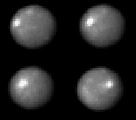
Pictures of the asteroid Ceres taken by the Hubble Space Telescope and released in 2005.

It shows the asteroid rotating over two hours and 20 minutes, which is about a quarter of a day on Ceres (nine hours).

At the time, scientists said the bright spot is a mystery.

Credit: NASA, ESA, J. Parker (Southwest Research Institute), P. Thomas (Cornell University), and L. McFadden (University of Maryland, College Park)

NASA / JPL / UCLA / MPS / DLR / IDA


Dawn's view of Ceres on December 1, 2014 (detail)


Round is so important to geologists. Round means that the force of gravity has overcome the strength of the materials

that make up Ceres, squishing it together and forcing its surface to be approximately flat, according to the local force of gravity;

over time, that makes a world round, not quite spherical, but bulging slightly at the equator.

 This reshaping by gravity generates heat in a couple of different ways, and heat encourages planetary materials to flow faster,

 sometimes even melting. Ceres will have tectonic features, maybe even an internal ocean.

 Or there were such features, once. Ceres' surface will have recorded those changes.

 It remains for Dawn to see whether those recordings have been preserved across geologic time,

 leaving a record that we, back on Earth, can decipher.
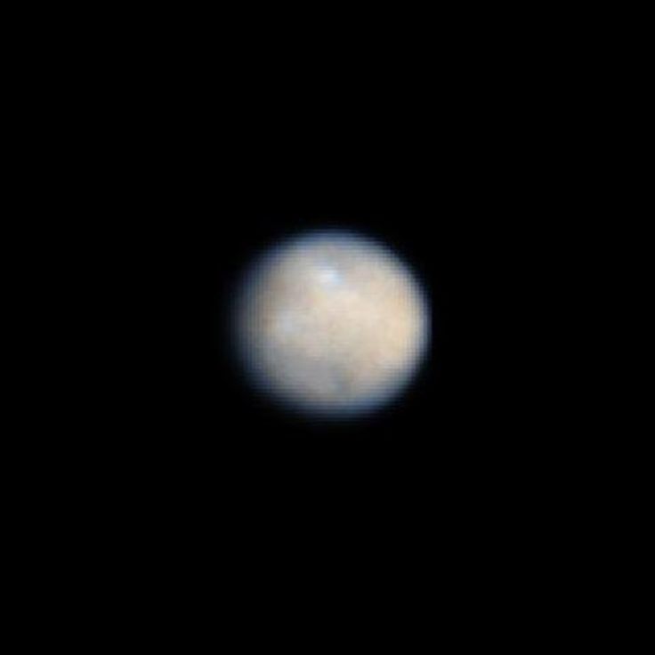
Ceres, Target of NASA's Dawn Mission Discovered on Jan. 1, 1801 by Giuseppe Piazzi of Italy,

Ceres is the largest object in the asteroid belt - the strip of solar system real estate between Mars and Jupiter.

On March 6, 2015, NASA's Dawn spacecraft will arrive at Ceres, marking the first time that a spacecraft has ever orbited two solar system target

Animation of Ceres made from Dawn images acquired on Jan. 13, 2015

(Credit: NASA/JPL-Caltech/UCLA/MPS/DLR/IDA/PSI)


Just sit back and watch the world turn� or should I say, watch the dwarf planet

turn in this fascinating animation from Dawn as the spacecraft continues on its ion-powered approach to Ceres!

Animation of  photos of the asteroid Ceres taken by NASA�s Dawn spacecraft on Feb. 4, 2015

at a distance of about 90,000 miles (145,000 kilometers). Credit: NASA/JPL-Caltech/UCLA/MPS/DLR/IDA

NASA�s Dawn spacecraft has acquired its latest and closest-yet snapshot of the mysterious dwarf planet world Ceres.

These latest images, taken on Feb. 4, from a distance of about 90,000 miles (145,000 km) clearly show craters �

including a couple with central peaks �  and a clearer though still ambiguous view of that wild white spot that has so many of us

scratching our heads as to its nature.

These two views of Ceres were acquired by NASA's Dawn spacecraft on Feb. 12, 2015,

from a distance of about 52,000 miles (83,000 kilometers) as the dwarf planet rotated.

 The images have been magnified from their original size.
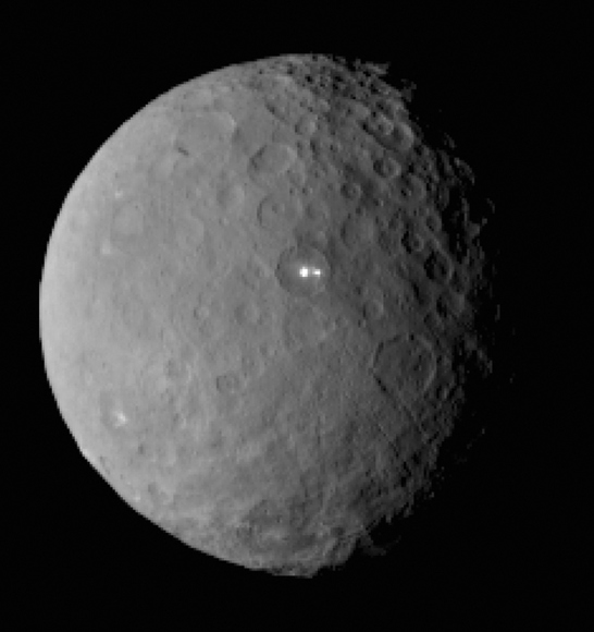
This image was taken by NASA�s Dawn spacecraft of dwarf planet Ceres on Feb. 19 from a distance of nearly 29,000 miles (46,000 km).

It shows that the brightest spot on the dwarf planet has a dimmer companion which lies in the same crater.

Note also the �cracks� or faults in its crust at bottom right.

 Credit: NASA/JPL-Caltech/UCLA/MPS/DLR/IDA

Ceres rotates in this sped-up movie comprised of images taken by NASA�s Dawn mission during its approach to the dwarf planet.

The images were taken on Feb. 19, 2015, from a distance of nearly 29,000 miles (46,000 kilometers).

 Dawn observed Ceres for a full rotation of the dwarf planet, which lasts about nine hours.

 The images have a resolution of 2.5 miles (4 kilometers) per pixel. Credit: NASA/JPL-Caltech/UCLA/MPS/DLR/IDA
Streamed live on Mar 2, 2015
NASA's Jet Propulsion Laboratory held a briefing at 9 a.m. PST (noon EST) Monday, March 2, to discuss the March 6 arrival of the agency's Dawn spacecraft at the dwarf planet Ceres. The news briefing, held at JPL's von Karman Auditorium at 4800 Oak Grove Dr., Pasadena, California, will be broadcast live on NASA Television and streamed here.

Ceres, located in the main asteroid belt between Mars and Jupiter, is the largest unexplored world of the inner solar system. Dawn will not only be the first spacecraft to reach a dwarf planet, it will be the first spacecraft ever to orbit two different worlds in deep space.

Dawn was the first spacecraft to orbit a body in the main asteroid belt when it explored the giant asteroid Vesta from 2011 to 2012.

Participants in the news conference are:

-- Jim Green, director, Planetary Science Division, NASA Headquarters, Washington

-- Robert Mase, Dawn project manager, JPL

-- Carol Raymond, Dawn deputy principal investigator, JPL
Category
Science & Technology
License
Standard YouTube License

Dawn�s framing camera took these images of Ceres on April 10, 2015 which were combined into a short animation.

 Credit: NASA/JPL-Caltech/UCLA/MPS/DLR/IDA

Brand new images taken on April 10 by NASA�s Dawn probe show the dwarf planet from high above its north pole.

 Photographed at a distance of just 21,000 miles (33,000 km) � less than 10 times the Earth-moon distance �

 they�re our sharpest views to date. The crispness combined with the low-angled sunlight gives Ceres a stark, lunar-like appearance.
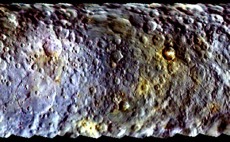
Dawn's first color map of Ceres shows the dwarf planet's mottled

surface hints at a vibrant and active past.
by Bob King on May 11, 2015
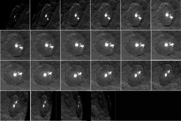
Where there were two, now there are 10! Ceres photographed on May 3 and 4 by NASA�s Dawn spacecraft

show multiple white spots inside the 57-mile-wide crater located in the asteroid�s  northern hemisphere.

 Credit: NASA/JPL-Caltech/UCLA/MPS/DLR/IDA / montage by Tom Ruen

This animation shows a sequence of images taken by NASA's Dawn spacecraft on May 4, 2015,

 from a distance of 8,400 miles (13,600 kilometers), in its RC3 mapping orbit.

 The image resolution is 0.8 mile (1.3 kilometers) per pixel.

Credits: NASA/JPL-Caltech/UCLA/MPS/DLR/IDA
Uploaded on Sep 8, 2015
Black and white and color animations made with new data from NASA's Dawn spacecraft highlight the topography of Occator crater on Ceres.
Category
Science & Technology
License
Standard YouTube License
by BOB KING on MAY 22, 2015
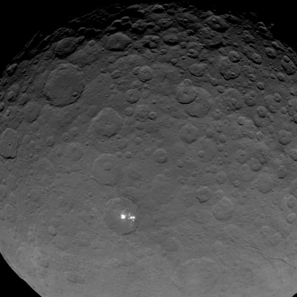
Latest image released by NASA of the white spots in the 57-mile-wide crater on the dwarf planet Ceres.

Scientists with the Dawn mission believe they’re highly reflective material, likely ice.

   Credit: NASA/JPL-Caltech/UCLA/MPS/DLR/IDA
by Mike Wall, Space.com Senior Writer | May 28, 2015 07:34pm ET
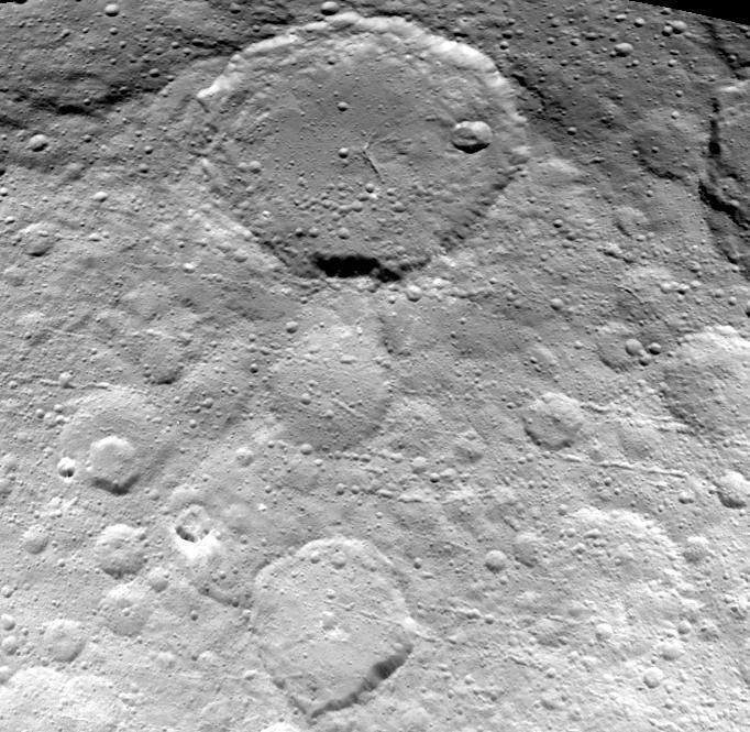
A new view of Ceres, captured by NASA’s Dawn probe on May 23, 2015, shows fine details of the dwarf planet’s surface coming into focus.
 into focus.
Credit NASA/JPL-Caltech/UCLA/MPS/DLR/IDA
NASA Jet Propulsion Laboratory
Published on Jun 8, 2015
A new video animation of dwarf planet Ceres, based on images taken by NASA's Dawn spacecraft, provides dramatic flyover views

of this heavily cratered, mysterious world. The images come from Dawn's first mapping orbit at Ceres,

at an altitude of 8,400 mile (13,600 kilometers), as well as navigational images taken from 3,200 miles (5,100 kilometers) away.

 The images provided information for a three-dimensional terrain model. The vertical dimension has been exaggerated by a factor of two,

 and a star field has been added in the background.

Category
Science & Technology
License
Standard YouTube License
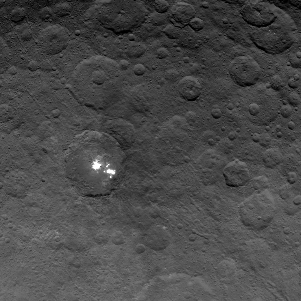
The brightest spots on dwarf planet Ceres are seen in this image taken by NASA’s Dawn spacecraft on June 6, 2015.

 This is among the first snapshots from Dawn’s second mapping orbit, which is 2,700 miles (4,400 km) in altitude.

The resolution is 1,400 feet (410 meters) per pixel. Click photos for full resolution images.

 Credit: NASA/JPL-Caltech/UCLA/MPS/DLR/IDA
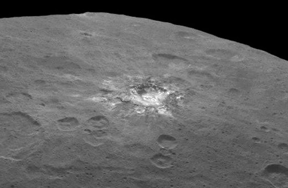
Fresh material is exposed in a rayed crater on Ceres. Taken on June 6 from 2,700 miles (4,400 km),

it has a resolution of 1,400 feet (410 meters) per pixel,

Credit: NASA/JPL-Caltech/UCLA/MPS/DLR/IDA
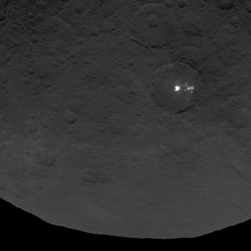
A cluster of mysterious bright spots on dwarf planet Ceres can be seen in this image,

taken by NASA's Dawn spacecraft from an altitude of 2,700 miles (4,400 kilometers).

 The image, with a resolution of 1,400 feet (410 meters) per pixel, was taken on June 9, 2015.

Topographic elevation map of Ceres showing newly-named craters.

The highest regions are in red, the lowest in blue.

Credit: NASA/JPL-Caltech/UCLA/MPS/DLR/IDA.

Russell said the ice-vs.-salt debate is continuing. “I originally was an advocate of ice,

because of how bright the spots seemed to be,” he said. However, the bright material’s albedo,

or reflectivity factor, is about 50 percent – which is less than Russell originally thought.

“This could be salt and is unlikely to be ice. I think the team opinion is now more in line with salt,” he said.

Ceres’ famous “bright spot” crater is now named Occator, after the Roman god of harrowing.

 (NASA/JPL-Caltech/UCLA/MPS/DLR/IDA)
Video caption: Take a tour of weird Ceres! Visit a 2-mile-deep crater and a 4-mile-tall mountain

in the video narrated by mission director Marc Rayman. Get your red/blue glasses ready for the finale

– a global view of the dwarf planet in 3D.

Credits: NASA/JPL-Caltech/UCLA/MPS/DLR/IDA/LPI/PSI
by NANCY ATKINSON on AUGUST 26, 2015

NASA’s Dawn spacecraft spotted this tall, conical mountain on Ceres from a distance of 915 miles (1,470 kilometers).

The mountain, located in the southern hemisphere, stands 4 miles (6 kilometers) high. Its perimeter is sharply defined,

 with almost no accumulated debris at the base of the brightly streaked slope. The image was taken on August 19, 2015.

 Credit: NASA/JPL-Caltech/UCLA/MPS/DLR/IDA

The brightest spots on the dwarf planet Ceres gleam with mystery in new views delivered

 by NASA's Dawn spacecraft. These closest-yet views of Occator crater, with a resolution of 450 feet (140 meters) per pixel,

 give scientists a deeper perspective on these very unusual features.

 CREDIT:NASA
by KEN KREMER on SEPTEMBER 30, 2015

This map-projected view of Ceres was created from images taken by NASA’s Dawn spacecraft during its high-altitude mapping orbit,

in August and September, 2015. This color coded map can provide valuable insights into the mineral composition of the surface, as well

as the relative ages of surface features.

 Credits: NASA/JPL-Caltech/UCLA/MPS/DLR/IDA

This mosaic shows Ceres’ Occator crater and surrounding terrain from an altitude of 915 miles

(1,470 kilometers), as seen by NASA’s Dawn spacecraft. Occator is about 60 miles (90 kilometers) across and 2 miles

 (4 kilometers) deep.

 Credits: NASA/JPL-Caltech/UCLA/MPS/DLR/IDA

Dawn’s low altitude mapping orbit LAMO. This shows how the orbit naturally shifts slightly (relative to the sun)
during the three months of LAMO, starting in blue and ending in red. The spacecraft completes each revolution in 5.5 hours,
and Ceres rotates in 9.1 hours, so Dawn will be able to view the entire surface.
Credit: NASA/JPL
This view from NASA’s Dawn spacecraft is a color-coded topographic map of Occator crater on Ceres.
Blue is the lowest elevation, and brown is the highest. The crater, which is home to the brightest spots on Ceres,
is approximately 56 miles (90 kilometers wide).
Credits: NASA/JPL-Caltech/UCLA/MPS/DLR/IDA
An artist’s conception shows NASA’s Dawn spacecraft flying above Ceres. This view incorporates actual imagery from the Dawn mission.
Credit: NASA/JPL-Caltech/UCLA/MPS/DLR/IDA
New Clues to Ceres’ Bright Spots and Origins Dec 10, 2015
Published on Dec 9, 2015 Dwarf planet Ceres is shown in these false-color renderings, which highlight differences in surface materials.
Images from NASA’s Dawn spacecraft were used to create a movie of Ceres rotating, followed by a flyover view of Occator Crater,
home of Ceres’ brightest area.
This representation of Ceres’ Occator Crater in false colors shows differences in the surface composition. Credits: NASA/JPL-Caltech/UCLA/MPS/DLR/IDA
About the Bright Spots Ceres has more than 130 bright areas, and most of them are associated with impact craters.
Study authors, led by Andreas Nathues at Max Planck Institute for Solar System Research, Göttingen, Germany,
write that the bright material is consistent with a type of magnesium sulfate called hexahydrite.
A different type of magnesium sulfate is familiar on Earth as Epsom salt.
-: See more
"The Global Nature of Ceres' bright spots suggests that this world has a subsurface layer that contains briny water ice" Nathues said
An image of Occator Crater draped over a digital terrain model provides a 3-D-like perspective view of the impact structure.
Credits: NASA/JPL-Caltech/UCLA/MPS/DLR/IDA - See more
A group of scientists from NASA’s Dawn mission suggests that when sunlight reaches Ceres’ Occator Crater,
a kind of thin haze of dust and evaporating water forms there.
Credits: NASA/JPL-Caltech/UCLA/MPS/DLR/IDA -
Published on Dec 29, 2015
Dwarf planet Ceres is shown in these false-color renderings, which highlight differences in surface materials.

 Images from NASA’s Dawn spacecraft were used to create a movie of Ceres rotating, followed by a flyover view of Occator Crater,

 home of Ceres’ brightest area.


Image credit: NASA/JPL-Caltech/UCLA/MPS/DLR/IDA
Category
Science & Technology
License
Standard YouTube License

This image from NASA’s Dawn spacecraft shows Kupalo Crater, one of the youngest craters on Ceres.

The crater has bright material exposed on its rim and walls, which could be salts. Its flat floor likely formed

from impact melt and debris.

 Credits: NASA/JPL-Caltech/UCLA/MPS/DLR/IDA

This image from NASA’s Dawn spacecraft shows part of Messor Crater (25 miles or 40 kilometers, wide),

located at northern mid-latitudes on Ceres. The scene shows an older crater in which a large lobe-shaped flow partly covers

the northern (top) part of the crater floor. The flow is a mass of material ejected when a younger crater formed just north of the rim.

 Credits: NASA/JPL-Caltech/UCLA/MPS/DLR/IDA

The fractured floor of Dantu Crater on Ceres is seen in this image from NASA’s Dawn spacecraft.

Similar fractures are seen in Tycho, one of the youngest large craters on Earth’s moon.

 This cracking may have resulted from the cooling of impact melt, or when the crater floor was uplifted after the crater formed.

 Credits: NASA/JPL-Caltech/UCLA/MPS/DLR/IDA
Published on Jan 29, 2016
Take a flight over dwarf planet Ceres in this video made with images from NASA's Dawn spacecraft.

 The simulated flyover was made by the mission's camera team at Germany's national aeronautics and space research center (DLR).

Category
Science & Technology
License
Standard YouTube License
The European Southern Observatory (ESO)
Published on Mar 16, 2016 This artist’s impression video is based on a detailed map of the surface compiled from images taken from
NASA’s Dawn spacecraft in orbit around the dwarf planet Ceres. It shows the very bright patches of material in the crater Occator
and elsewhere. New observations using the HARPS spectrograph on the ESO 3.6-metre telescope at La Silla in Chile have revealed
unexpected daily changes on these spots, suggesting that they change under the influence of sunlight as Ceres rotates.
This illustration shows how the features in the spectrum of the light reflected from the bright spots is alternately
red and blue shifted slightly compared to the average light of Ceres as it rotates. This very subtle effect has been
measured from the ground using the HARPS spectrograph on the ESO 3.6-metre telescope at La Silla in Chile.
The effect has been greatly exaggerated to make it visible and excludes the much brighter light coming from the rest of the disc of Ceres. More information and download options: http://www.eso.org/public/videos/eso1... Credit: ESO/L.Calçada/NASA/JPL-Caltech/UCLA/MPS/DLR/IDA/Steve Albers Category Science & Technology License Standard YouTube License

The bright central spots near the center of Occator Crater are shown in enhanced color

in this view from NASA’s Dawn spacecraft. The view was produced by combining the highest resolution images

 taken in February 2016 at an image scale of 115 feet (35 meters) per pixel with color images obtained in

 September 2015 at a lower resolution added. Click for a highest-res view.

 Credit: NASA/JPL-Caltech/UCLA/MPS/DLR/IDA/PSI

Occator Crater, measuring 57 miles (92 kilometers) across and 2.5 miles (4 kilometers) deep,

 contains the brightest area on Ceres.

 Credit: NASA/JPL-Caltech/UCLA/MPS/DLR/IDA/PSI

This global map shows the surface of Ceres in enhanced color, including infrared wavelengths beyond human visual range.

 Photos were taken using infrared, green and blue filters and combined to create this view.

 Credit: NASA/JPL-Caltech/UCLA/MPS/DLR/IDA/PSI

This global map shows the surface of Ceres in enhanced color, including infrared wavelengths beyond human visual range.

 Photos were taken using infrared, green and blue filters and combined to create this view.

 Credit: NASA/JPL-Caltech/UCLA/MPS/DLR/IDA/PSI

April 20, 2016
A newly-released photograph from NASA provides an amazingly colorful view of the surface of the dwarf planet Ceres,

 including a crater which boasts an incredibly unique shape.

The impression, dubbed 'Haulani Crater,' sports remarkably straight lines that leave the site resembling a rudimentary stop sign (Octogon).
The straight-edged nature of the crater was noted by NASA as quite different from similar locations found throughout space so far.
Calling attention to the area, the space agency observed that "most craters seen on other planetary bodies, including Earth, are nearly circular."
They went on to credit "pre-existing stress patterns and faults beneath the surface" for the odd shape of the crater.
The new image also provides another look at the infamous 'bright spots' on Ceres which set of a firestorm of speculation in the paranormal community last year.
Despite NASA's explanations for both oddities, it's likely that this new image will only further pique the interest of space anomaly

watchers who suspect that there is a much bigger story behind Ceres than merely a dwarf planet.
Source: Christian Science Monitor

A depression on Ceres is possibly what’s left of one of the largest craters from Ceres’ earliest collisional history.

 Credit: SwRI/Simone Marchi.

Scientists with NASA’s Dawn mission were surprised to find that Ceres has no clear signs

of truly giant impact basins. This image shows both visible (left)
and topographic (right) mapping data from Dawn.

Credit: NASA/JPL-Caltech/SwRI.
Published on Jul 26, 2016
Ceres' lack of giant impact basins presents a puzzle to scientists. They expected to observe more large craters

on the dwarf planet than have been found by NASA's Dawn mission. Researchers are investigating a variety of processes

 that might have caused the appearance of the largest basins to be softened or erased over time. For more information

 about the Dawn mission,  visit
Category
Science & Technology
License
Standard YouTube License

This artist's concept shows a diagram of how the inside of Ceres could be structured, based on data about the dwarf planet's gravity field

 from NASA's Dawn mission.

Using information about Ceres' gravity and topography, scientists found that Ceres is "differentiated,"

 which means that it has compositionally distinct layers at different depths. The densest layer is at the core,

 which scientists suspect is made of hydrated silicates. Above that is a volatile-rich shell, topped with a crust of mixed materials.

Whoa – what a sight! Ceres’ lonely mountain, Ahuna Mons, is seen in this simulated perspective view.

The elevation has been exaggerated by a factor of two. The view was made using enhanced-color images

 from NASA’s Dawn mission in August from an altitude of 240 miles (385 km) in August 2016.

 Credit: NASA/JPL-Caltech/UCLA/MPS/DLR/IDA/PSI

Ahuna Mons is seen in this mosaic of images from NASA’s Dawn spacecraft. On its steepest side,

 this mountain is about 3 miles (5 km) high. Its average overall height is 2.5 miles (4 km).

 The diameter of the mountain is about 12 miles (20 km). Dawn took these images from its low-altitude mapping orbit,

 240 miles (385 kilometers) above the surface, in December 2015.
Credits: NASA/JPL/Dawn mission

The Ahuna Mons dome compared to a dome in Russia. The similarity in appearance is striking though the difference in size is large. Credit: NASA
Published on Sep 1, 2016
Analysis of images from NASA's Dawn mission reveals that dwarf planet Ceres hosts an unexpectedly young cryovolcano that formed with the past billion years.

 Read the full NASA.gov story here:

Read the full paper in Science here: [link]

 For more Ceres images and animations, visit the JPL Photojournal:

Music credits:
"Farewell to the King" by Richard Friedman [ASCAP]; Jefandyo Music SESAC; Killer Tracks Production Music
"Out of Control" by Amanda Leigh Wilson [PRS] and Stephen William Cornish [PRS]; Atmosphere Music Ltd PRS; Killer Tracks Production Music
"Seven Sitars" by Chris Constantinou [PRS] and Paul Frazer [PRS]; Killer Tracks BMI; Killer Tracks Production Music

Credit: NASA's Goddard Space Flight Center/Katrina Jackson

This video is public domain and along with other supporting visualizations can be downloaded from the Scientific Visualization Studio at: https://svs.gsfc.nasa.gov/12346

: If you liked this video, subscribe to the NASA Goddard YouTube channel

Or subscribe to NASA’s Goddard Shorts HD Podcast:

Follow NASA’s Goddard Space Flight Center

 · Facebook:

 · Twitter

 · Flickr

 · Instagram

+· Google
Category
Science & Technology
License
Standard YouTube License

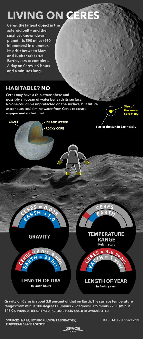
Dwarf planet Ceres is located in the asteroid belt, between the orbits of Mars and Jupiter.

 Observations by ESA’s Herschel Space Observatory between 2011 and 2013 found that the dwarf planet

 has a thin water-vapor atmosphere, the first detection ever of water vapor around an asteroid in the asteroid belt.

 Copyright ESA/ATG medialab/Küppers et al.

The small, bright crater Oxo (6 miles / 10 km wide) on Ceres is seen in this perspective view.

 The elevation has been exaggerated by a factor of two. The view was made using enhanced-color images from NASA’s Dawn mission.

 Dawn’s visible and infrared mapping spectrometer (VIR) has found evidence of water ice at this crater.

 Credit: NASA/JPL-Caltech/UCLA/MPS/DLR/IDA

In this illustration, a mud slurry rises up through Ceres’ crust to build a dome like Ahuna Mons.

 Credit: Goddard Media Studios

The rim of Hamori Crater on Ceres is seen in the upper left portion of this image, which was taken by NASA’s Dawn spacecraft.

 Clay is found at many locations on the dwarf planet.

 Credit: NASA/JPL-Caltech/UCLA/MPS/DLR/IDA

Graphic showing a theoretical path of a water molecule on Ceres. Some water molecules fall into cold, dark craters
 called “cold traps,” where very little of the ice turns into vapor, even over the course of a billion years.
 Credit: NASA/JPL-Caltech/UCLA/MPS/DLR/IDA
The concentrations of iron, potassium and carbon detected by the GRaND instrument also supports the theory
 that Ceres’ surface was altered by liquid water in the interior. Basically, scientists theorize that the decay
 of radioactive elements within Ceres created enough heat to cause the protoplanet’s structure to differentiate
 between a rocky interior and icy outer shell – which also allowed minerals like those observed to be deposited in the surface.
Published on Dec 15, 2016
This video shows the intriguing Occator Crater on Ceres, home to the dwarf planet's brightest area.
 It may have been produced by upwelling of salt-rich liquids after the impact that formed the crater.
 The animated flyover includes topographic and enhanced-color views of the crater, highlighting the central dome feature.
 The animation was produced by the German Aerospace Center (DLR). Original music by Stefan Elgner, DLR.

 For more information about the Dawn mission, visit

Image Credit:
NASA/JPL-Caltech/UCLA/MPS/DLR/IDA
Category
Science & Technology
License
Standard YouTube License

Image: This animation shows how the illumination of Ceres’ northern hemisphere varies with the dwarf planet’s axial tilt,
or obliquity. Shadowed regions are highlighted for tilts of 2 degrees, 12 degrees and 20 degrees.
 Credit: NASA/JPL-Caltech/UCLA/MPS/DLR/IDA.

This image of Ceres approximates how the dwarf planet's colors would appear to the eye.
 Credit: NASA/JPL-Caltech/UCLA/MPS/DLR/IDA

Dwarf planet Ceres is located in the asteroid belt, between the orbits of Mars and Jupiter.

 Observations by ESA’s Herschel Space Observatory between 2011 and 2013 found that the dwarf planet

 has a thin water-vapor atmosphere, the first detection ever of water vapor around an asteroid in the asteroid belt.

 Copyright ESA/ATG medialab/Küppers et al.

NASA’s Dawn spacecraft determined the hydrogen content of the upper yard, or meter, of Ceres’ surface.
 Blue indicates where hydrogen content is higher, near the poles,
while red indicates lower content at lower latitudes.
 Image credit: NASA/JPL-Caltech/UCLA/MPS/DLR/IDA/PSI

A view of Ceres in natural colour, pictured by the Dawn spacecraft in May 2015.
 Credit: NASA/ JPL/Planetary Society/Justin Cowart

Ceres. as imaged by the NASA Dawn probe.
 Credit: NASA/JPL-Caltech/UCLA/MPS/DLR/IDA

Diagram showing a possible internal structure of Ceres.
 Credit: NASA/ESA/STScI/A. Feild

Gravity measurements of Ceres, which provided  hints about its internal structure.
Credit: NASA/JPL-Caltech/UCLA/MPS/DLR/IDA
Finite element modeling of Ceres’ topography [Fu et al., 2017] shows that the topographic power
 cannot be supported by a solely ice rheology [physics dealing with the deformation and flow of matter]
 over billion year timescales. Using a lower bound for crustal density based on rheology,
 we derive constraints on the crustal thickness using the assumption of hydrostatic equilibrium.
 A low-density, high strength mixture is required to explain the inferred crustal density and rheology.
 The latter does not allow more than 43 vol% silicates assuming 15% void porosity in the crust.
 Therefore, lower density materials, such as salt or gas (clathrate) hydrates, are required.

Image: This animation shows Ceres as seen by NASA’s Dawn spacecraft from its high-altitude mapping orbit
at 1,470 kilometers above the surface. The colorful map overlaid at right shows variations in Ceres’ gravity field measured by Dawn,
and gives scientists hints about the dwarf planet’s internal structure. Red colors
 indicate more positive values, corresponding to a stronger gravitational pull than expected, compared
 to scientists’ pre-Dawn model of Ceres’ internal structure;blue colors
 indicate more negative values, corresponding to a weaker gravitational pull.
 Credit: NASA/JPL-Caltech/UCLA/MPS/DLR/IDA.

A visual image and a gravitational field image of Ceres. Note the area of strong gravity at Ahuna Mons,in white.
 Image Credit: NASA/JPL-Caltech/UCLA/MPS/DLR/IDA

Ahuna Mons on the dwarf planet Ceres is a remarkable and unique feature in our Solar System.
 Image Credit: NASA/JPL-Caltech/UCLA/MPS/DLR/IDA

These are Dawn’s best images of Ahuna Mons, captured when the spacecraft was at its closest point
 to the surface. Note the smooth, craterless sides of the volcano, a clue that it is younger
 than the rest of the dwarf planet’s surface.
 Image Credit: NASA/JPL-Caltech/UCLA/MPS/DLR/IDA

This model of Ceres’ structure was created from data from the Dawn mission.
The 40km thick crust is composed of ice, salts, and hydrated minerals.
 Beneath that there is likely a layer of brine and mud, and under that,
 the rocky mantle is made of mostly hydrated minerals.
 Scientists don’t know if Ceres has a rocky core.
Image Credit: NASA/JPL-Caltech/UCLA/MPS/DLR/IDA

A color-coded gravity map of Ahuna Mons created with Dawn data. Ahuna Mons,
at it’s highest point, rises almost 5 km (3.1 miles) above its surroundings.
 There’s a 9 km (5.6 mile) elevation distance from the peak of the volcano
 to the low-lying areas shown in blue.
 Image Credit: NASA/JPL-Caltech/UCLA/MPS/DLR/IDA
Additional Information Mr. Hoagland's research
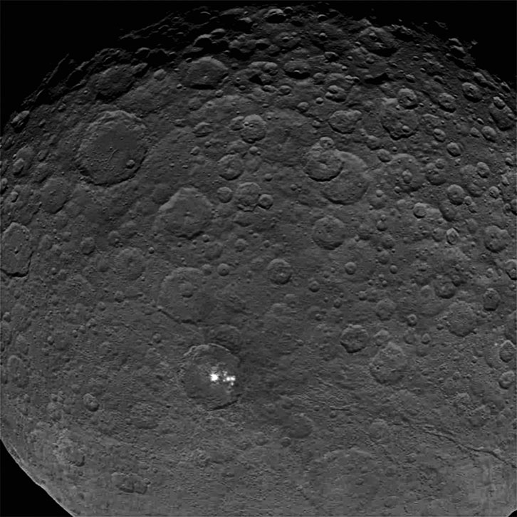
As NASA's unmanned DAWN spacecraft approached the largest asteroid, Ceres,

in March, 2015, it imaged two remarkable sets of "lights" lying in the bottom of a 55-mile-wide crater.

 Determined to be intense reflections (~100%) of the weak sunlight illuminating the rest Ceres' extremely dark surface,

 the fundamental nature of these intense solar reflections still remains(as of June 18, 2015) totally unknown.
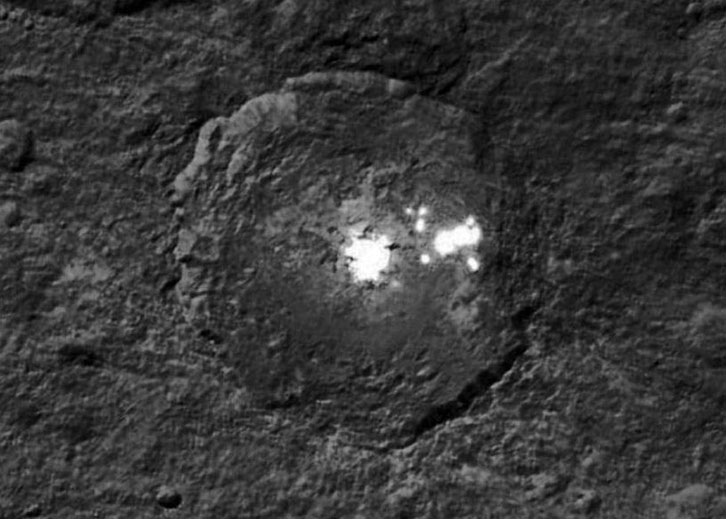
A closer DAWN image of the "Ceres Lights," revealing the remarkable miles-wide geometry

and "organized" placement of both the main reflections, as well as the attendant "satellite" reflections.

A natural explanation for this highly-organized collection is increasingly unlikely, according to Enterprise Mission analysis.

The most startling aspect of the "Ceres Lights" lies in their geographic placement on Ceres' surface --

precisely at 19.5 degrees! This specific latitude has been identified in other Enterprise research as a key

location for both natural geophysical energy upwellings, as well as the deliberate siting of ancient artificial structures on Earth.
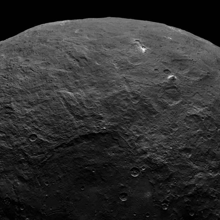
This wide-angle DAWN image shows another unique feature on the Ceres' surface --

 a 3-mile-high "pyramid" Ascribed to a natural "cryovolcanic" process by some NASA specialists,

 the Enterprise Mission suspects this remarkable feature could have a much more interesting explanation:

 as the 3-mile-high ruins of a former "ancient glass arcology" (a contained living environment).
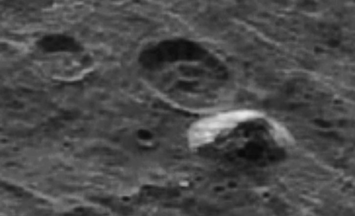
Close-up DAWN image of the possible "3-mile-high, ancient arcology" on Ceres.

Note the complex interior layering and sharp, geometric "base."

An equally puzzling geometgric feature seems to lie in an adjacent crater.

Future imaging of these remarkable features from the DAWN spacecraft will be from a hundred times closer,

 and should reveal if the Enterprise "artificial model" is correct.
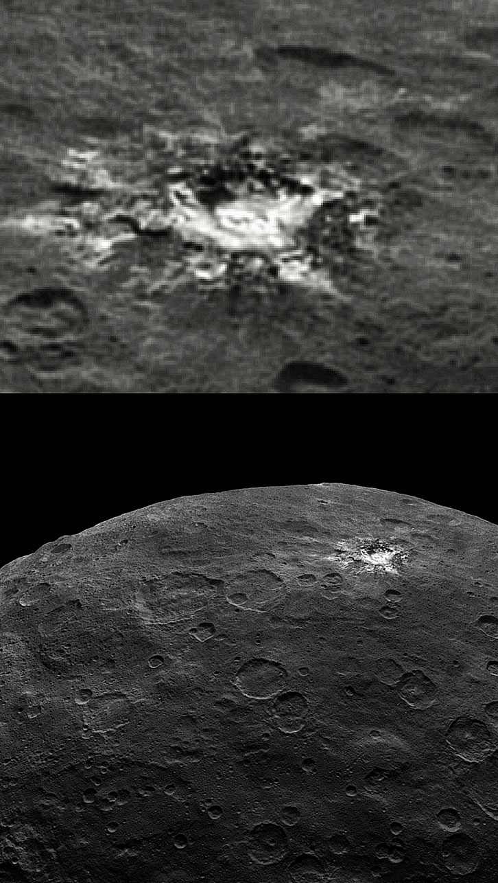
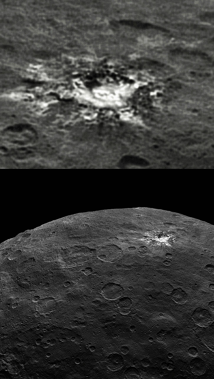
This DAWN comparison (prepared by Enterprise Mission Associate, Ron Gerbron)

reveals another "anomalous, geometric complex" on the Ceres surface.

 Measuring about fifty miles across, the three-dimensional, geometric nature of the bright,

 more reflective structures really stands out against the much darker (less reflective) surrounding Ceres'

 surface. Again, closer planned imaging should be 100 times better than this version --

 allowing scientific determination of the reason for the amazing interior geometry.
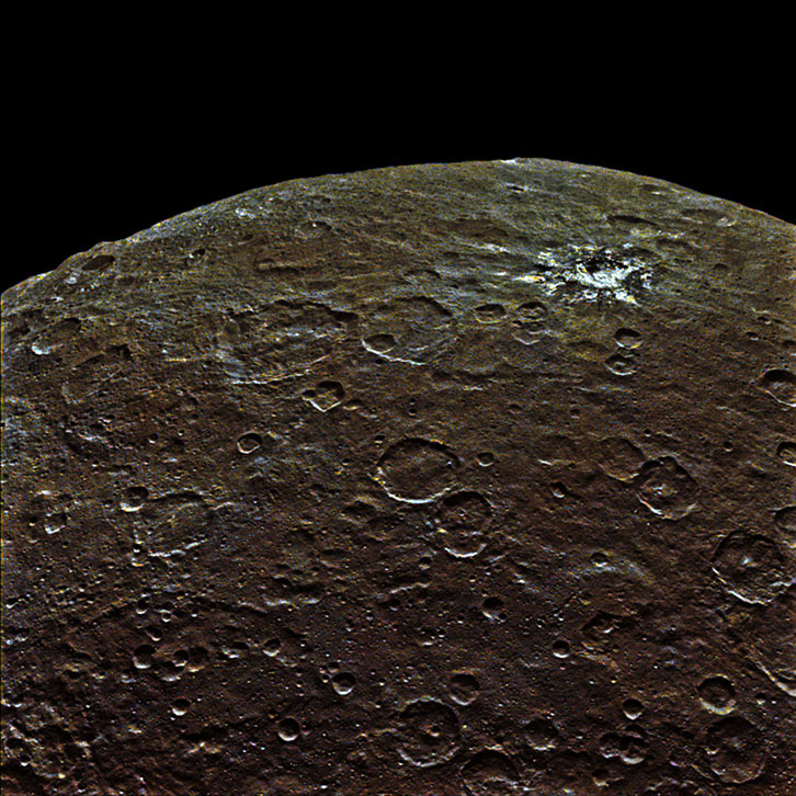
This "virtual color" version of the previous DAWN image reveals the remarkable,

 highly reflective glass-like nature of this Cerean geometry. If these, indeed, are "ruins,"

 future DAWN imaging should allow positive determination by late Fall.
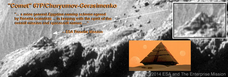
This startling Rosetta image comparison -- between a layered, sharply artiifical-looking pyramid-

like structure on Comet 67P, and a fictional "G'ould Pyramid Ship" in the Hollywood film "Stargate" --

 is only one of hundreds of equally remarkable "ancient ruins" studding the surface of this "comet."

 Future, closer imaging by the European Rosetta spacecaft may provide enough detail

 for a more conclusive determination of the origins of this and all the other "anomalous features" on 67P.

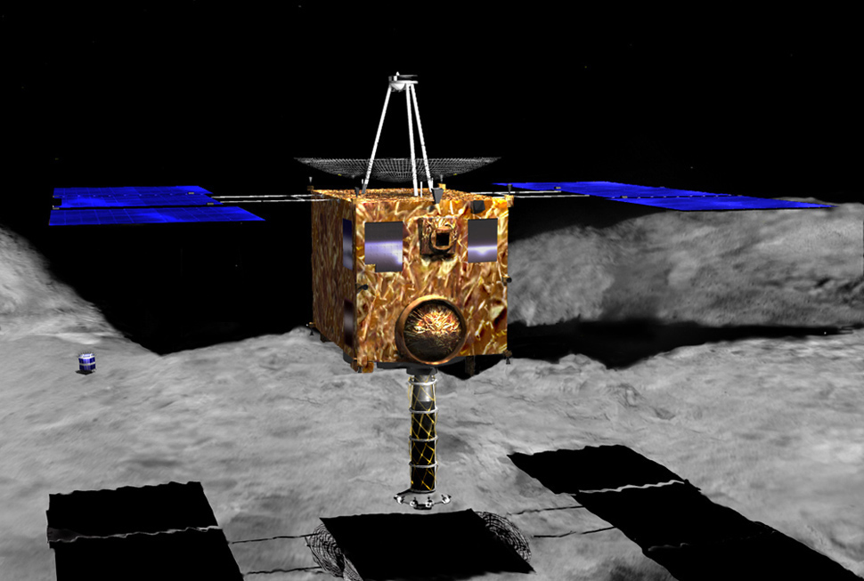
Artist Conception of the Hayabusa2 spacecfaft landing on Ryugu

n December of 2014, the Japanese Aerospace Exploration Agency (JAXA) launched the Hayabusa2 mission.
As the second spacecraft to bear this name, Hayabusa2 was deployed by JAXA to conduct a sample-return mission
 with an asteroid. By studying samples of the near-Earth asteroid 162173 Ryugu, scientists hope to shed new light
 on the history of the early Solar System

Artist’s conception of the MINERVA-II1 rovers.
Credit: JAXA
Rover-1B shot a 15-frame movie on asteroid Ryugu’s surface. This movie covers a little over an hour,
 9:34 a.m. to 10:48 a.m. EDT, on September 22. “Enjoy ‘standing’ on the surface of this asteroid!”
 the Hayabusa2 team tweeted.

  Read more:

Image of Ryugu captured by the ONC-T on September 21st, 2018. This is the highest resolution photograph
 obtained of the surface of Ryugu. Bottom left is a large boulder.
 Credit: JAXA
Region of the highest resolution image.  Yellow boxes correspond
 to the region in Figure 1.
 Credit: JAXA

Earlier this week asteroid Ryugu had a visitor. The Mobile Asteroid Surface Scout (MASCOT)
 landed on Ryugu on October 3rd after it was successfully deployed from the Japanese Hayabusa2
 space probe. The little hopping robot’s visit was brief however, and it stopped functioning on Oct. 4th 2018.

MASCOT Lander
Verified account
@MASCOT2018
Follow Follow @MASCOT2018
More
Check this out! I took this picture when I was almost on #Ryugu's surface. Look at how sunlight is
reflected off me. What a dark surface!
Credit: MASCOT/@DLR_en /@JAXA_en #AsteroidLanding

An artist’s illustration of MASCOT, the French-German hopping robot, on the surface of asteroid Ryugu.
 Image: Credit: DLR (CC-BY 3.0)

An artist’s illustration of MASCOT, the little hopping robot, on the surface of asteroid Ryugu.
Image Credit: DLR (CC-BY 3.0)

MASCOT the hopping robot attached to Hayabusa2 before deployment.
 Artist’s illustration. Image Credit: DLR (CC-BY 3.0)

MASCOT’s path across the surface of asteroid Ryugu. The path was recreated using data
from the robot and from the mother probe Hayabusa2. Hayabusa2’s shadow is visible at the bottim right.
 The yellow line is the robot’s flight path down to the asteroid,
and the blue line is the projection of these points onto Ryugu’s surface.
 The blue line  heading towards the right of the image is MASCOT’s path
 along Ryugu’s surface.
 Image Credit: DLR/JAXA

The MASCAM camera captured the image on the right during MASCOT descent to Ryugu.
 The white triangle in the left image shows the area covered by the image on the right.
 Scientist’s are puzzled by the lack of fine dust and rock on the asteroid.
 Image Credit: MASCOT/DLR/JAXA

MASCAM captured the image on the right as it tumbled toward Ryugu’s surface.
 A huge boulder tens of meters wide casts a dark shadow.
 The image on the left contains a white open trapezoid, showing the direction of the image on the right.
 Image: MASCAM/DLR/JAXA
Japan’s Hayabusa2 mission is about to get down to business. After arriving at asteroid Ryugu
at the end of June 2018, and dispatching its tiny rovers to the surface, the spacecraft is about
to approach the surface of the asteroid and get some samples.

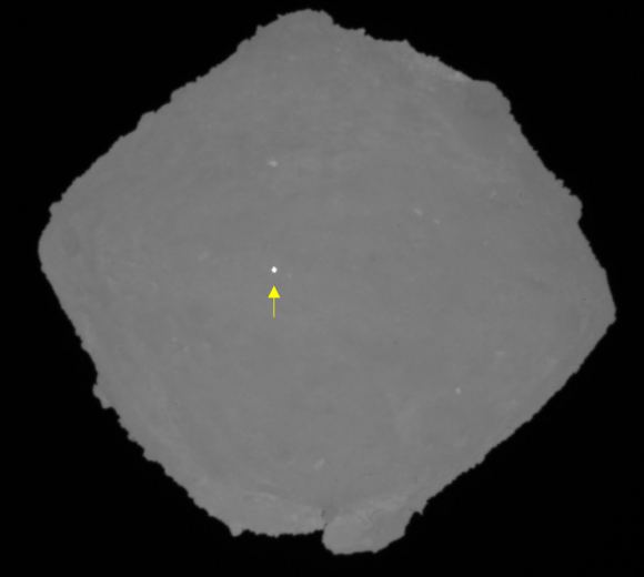
An image of Ryugu captured by the Optical Navigation Camera – Telescopic. The white dot
 is the target marker that marks the landing site for Hayabusa2’s first sample collection.
 Image Credit: JAXA, University of Tokyo, Kochi University, Rikkyo University,
 Nagoya University, Chiba Institute of Technology, Meiji University, University of Aizu, AIST.

A well-lit image of the surface of Ryugu, captured by the Optical Navigation Camera –
 Telescopic on Hayabusa2 during BOX-B maneuvers. The red arrow marks the landing spot.
 Image Credit: JAXA, University of Tokyo, Kochi University, Rikkyo University,
 Nagoya University, Chiba Institute of Technology, Meiji University, University of Aizu, AIST.

An image from one of Hayabusa2’s close approaches to Ryugu. The silhouette of the spacecraft
is clearly visible. Hey, it looks like a Canada flag!
 Image Credit: JAXA
Click on the gray screen to start
小惑星探査機「はやぶさ2」に装備されている4種類のリモートセンシング機器の機能および科学観測のしくみについて説明します。(2016年3月制作)

この映像ソフトはDVDによる貸出が可能です。
貸出をご希望の方はこちらのリンクをご参照ください。
http://www.jaxa.jp/projects/pr/video/

※ 映像中に、赤い光が点滅する表現があります。テレビや大画面で観る際は、部屋を明るくして画面から離れてご覧ください。

【関連動画】
各機器開発者のビデオメッセージ(2014年11月に撮影):

サンプリング装置・分離カメラ・光学航法カメラ担当 澤田 弘崇
http://youtu.be/b3oH1AtIgnY?list=PLCQ...

光学航法カメラ[理学]・科学観測担当 杉田 精司
https://youtu.be/FfY4c80Kjys?list=PLC...

近赤外分光計NIRS3担当 岩田 隆浩
http://youtu.be/lHEg12f7KUs?list=PLCQ...

中間赤外カメラ(TIR) 担当 田中 智
http://youtu.be/XnX9_j2tVF8

中間赤外カメラ(TIR) 担当 岡田 達明
http://youtu.be/qOq-qQ48myM

レーザ高度計(LIDAR)担当 水野 貴秀
https://www.youtube.com/watch?v=xKyjy...

レーザ高度計(LIDAR)[理学]担当 並木則行
https://youtu.be/P1ymUoEUwYc?list=PLC...

光学航法カメラのデータ処理機器担当 大嶽 久志
https://www.youtube.com/watch?v=O81NK...


【関連サイト】
はやぶさ2プロジェクト
http://www.hayabusa2.jaxa.jp/

はやぶさ2特設サイト 観測機器
http://fanfun.jaxa.jp/countdown/hayab...

Japan’s Hayabusa2 spacecraft has completed an important part of its mission to asteroid Ryugu.
 The spacecraft descended to the surface of the asteroid to collect two samples with its sampling horn.
 We don’t know for sure if samples were successfully collected,
 but all indications are that the sampling mission went well.

This is an exciting accomplishment for JAXA, and marks their second successful asteroid sampling mission,
 following the success of the first Hayabusa mission to the asteroid Itokawa.

Image captured near the touchdown site immediately after touchdown.
 Credit: JAXA/University of Tokyo/Kochi University/Rikkyo University/Nagoya University/Chiba
 Institute of Technology/Meiji University/University of Aizu/AIST

The planned touchdown site and target marker before Hayabusa2 landed.
 Credit: JAXA, University of Tokyo/Kochi University/Rikkyo University/Nagoya
 University/Chiba Institute of Technology/Meiji University/University of Aizu/AIST
Click on the gray screen to start

小惑星探査機「はやぶさ2」に装備されている4種類のリモートセンシング機器の機能および科学観測のしくみについて説明します。(2016年3月制作)

この映像ソフトはDVDによる貸出が可能です。
貸出をご希望の方はこちらのリンクをご参照ください。
http://www.jaxa.jp/projects/pr/video/

※ 映像中に、赤い光が点滅する表現があります。テレビや大画面で観る際は、部屋を明るくして画面から離れてご覧ください。

【関連動画】
各機器開発者のビデオメッセージ(2014年11月に撮影):

サンプリング装置・分離カメラ・光学航法カメラ担当 澤田 弘崇
http://youtu.be/b3oH1AtIgnY?list=PLCQ...

光学航法カメラ[理学]・科学観測担当 杉田 精司
https://youtu.be/FfY4c80Kjys?list=PLC...

近赤外分光計NIRS3担当 岩田 隆浩
http://youtu.be/lHEg12f7KUs?list=PLCQ...

中間赤外カメラ(TIR) 担当 田中 智
http://youtu.be/XnX9_j2tVF8

中間赤外カメラ(TIR) 担当 岡田 達明
http://youtu.be/qOq-qQ48myM

レーザ高度計(LIDAR)担当 水野 貴秀
https://www.youtube.com/watch?v=xKyjy...

レーザ高度計(LIDAR)[理学]担当 並木則行
https://youtu.be/P1ymUoEUwYc?list=PLC...

光学航法カメラのデータ処理機器担当 大嶽 久志
https://www.youtube.com/watch?v=O81NK...


【関連サイト】
はやぶさ2プロジェクト
http://www.hayabusa2.jaxa.jp/

はやぶさ2特設サイト 観測機器
http://fanfun.jaxa.jp/countdown/hayab...

The location of where Hayabusa2 will conduct its second Crater Search Operation (CRA2).
Credit: JAXA

Japan’s Hayabusa 2 spacecraft is now the first spacecraft to retrieve a subsurface sample from an asteroid.
On July 11th,2019 the spacecraft touched down for a second time on asteroid 162173 Ryugu.
 This time, the probe retrieved a sample from a crater it excavated with its impactor.

The SCI above Ryugu after being deployed by Hayabusa 2. It didn’t fire its projectile
into the asteroid until the spacecraft had travelled to a safe distance away from any debris.
 Image: JAXA

DCAM 3 captured this image of the SCI impact on 5 April 2019. The impact debris is a small spray
of dust against the black of space, near the top-right limb of the asteroid.
 Image: JAXA

[PPTD] These images were taken immediately after today’s touchdown (Jul 11, 2019) with the ONC-W1.
 First photo was taken at 10:06:32 JST (on-board time) and you can see the gravel flying upwards.
 Second shot was at 10:08:53 where the darker region near the centre is due to touchdown.

Asteroid Ryugu, as imaged by the Hayabusa2 spacecraft. The red dot marks the sampling location
  Image Credit: JAXA/Hayabusa2
*Please Watch to the End
** Watch in HD and Full Screen

As always, look for the picture links at the bottom of the description. Thanks for Watching! Best Regards, Chris....

IMAGE CREDIT GOES TO: ESA / NASA / JPL / University of Arizona / Caltech / Msss

** These pictures are made public to the people**

Thanks for watching! If you guys like what you see,
please SUBSCRIBE and don't forget to give me a thumbs up! Its greatly appreciated!

  Check out the other Mars Team Members videos here:  (bottom of page)

NASA LINK:

Hubble image of the galaxy cluster Abell 370, showing the trails caused by 22 Near-Earth Asteroids.
Credit: NASA, ESA, and B. Sunnquist and J. Mack (STScI)
 Acknowledgment: NASA, ESA, and J. Lotz (STScI) and the HFF Team

Artist’s impression of a Near-Earth Asteroid passing by Earth.
 Credit: ESA